
Dosya:Map of Indians Texas 1500.png

Bu önizlemenin boyutu: 800 × 549 piksel. Diğer çözünürlükler: 320 × 220 piksel | 640 × 439 piksel | 1.024 × 703 piksel | 1.280 × 878 piksel | 2.308 × 1.584 piksel.
Tam çözünürlük ((2.308 × 1.584 piksel, dosya boyutu: 521 KB, MIME tipi: image/png))
Bu dosya Wikimedia Commons'ta bulunmaktadır. Dosyanın açıklaması aşağıda gösterilmiştir. Commons, serbest/özgür telifli medya dosyalarının bulundurulduğu depodur. Siz de yardım edebilirsiniz. |
Özet
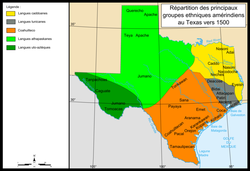
| Açıklama | Map of Texas showing the location of Indian groups around 1500 as well as colors showing regions in which specific Indian languages were spoken. The Southwest of Texas is colored dark green for Lagues uo-azteques, and the groups in this region are Tanpachaos, Caguate, Jumano, and Tomoacas. The northwest is colored lime green for the Langues Athapaskanes and the groups in this area are the Querecho, Apache, Teya, and Jumano. The large southern section in the middle of the map is colored orange for Coahuilteco, and the groups in this region are the Tonkawan, Sana, Payaya, Emet, Coca, Aranama, Coahuiltecan, Karankawan, Kopano, Kahani, Orejon, Pacal, and Tamaulipecan. A small eastern section along the coast is colored grey for Langues tunicanes, and includes the groups Deacose, Bidai, Attacapan, Patiri, Akokna, and Atacapa. The northeast of the state is colored yellow for Langues caddoanes, and contains the groups of Nasoni, Caddo, Adai, Nacodoche, Neches, and Eyeish. |
| Tarih | 13 Eylül 2008 (original upload date) |
| Kaynak | No machine-readable source provided. Own work assumed (based on copyright claims). |
| Yazar | No machine-readable author provided. Urban~commonswiki assumed (based on copyright claims). |
Lisanslama
| Ben, bu işin telif sahibi, bu işi kamu malı olarak yayınlıyorum. Bu dünya çapında geçerlidir. Bazı ülkelerde bu yasal olarak mümkün olmayabilir; öyleyse: Ben, bu işi herhangi bir amaç için, herhangi bir şart olmaksızın, yasalarca gerekli olmadıkça, herkesin kullanmasına izin veriyorum. |
Dosya geçmişi
Dosyanın herhangi bir zamandaki hâli için ilgili tarih/saat kısmına tıklayın.
| Tarih/Saat | Küçük resim | Boyutlar | Kullanıcı | Yorum | |
|---|---|---|---|---|---|
| güncel | 15.10, 13 Eylül 2008 | | 2.308 × 1.584 (521 KB) | Urban~commonswiki | category:maps of Texas |
Dosya kullanımı
Bu görüntü dosyasına bağlantısı olan sayfalar:
Küresel dosya kullanımı
Aşağıdaki diğer vikiler bu dosyayı kullanır:
- bo.wikipedia.org üzerinde kullanımı
- ca.wikipedia.org üzerinde kullanımı
- en.wikipedia.org üzerinde kullanımı
- es.wikipedia.org üzerinde kullanımı
- fr.wikipedia.org üzerinde kullanımı
- it.wikipedia.org üzerinde kullanımı
- sr.wikipedia.org üzerinde kullanımı