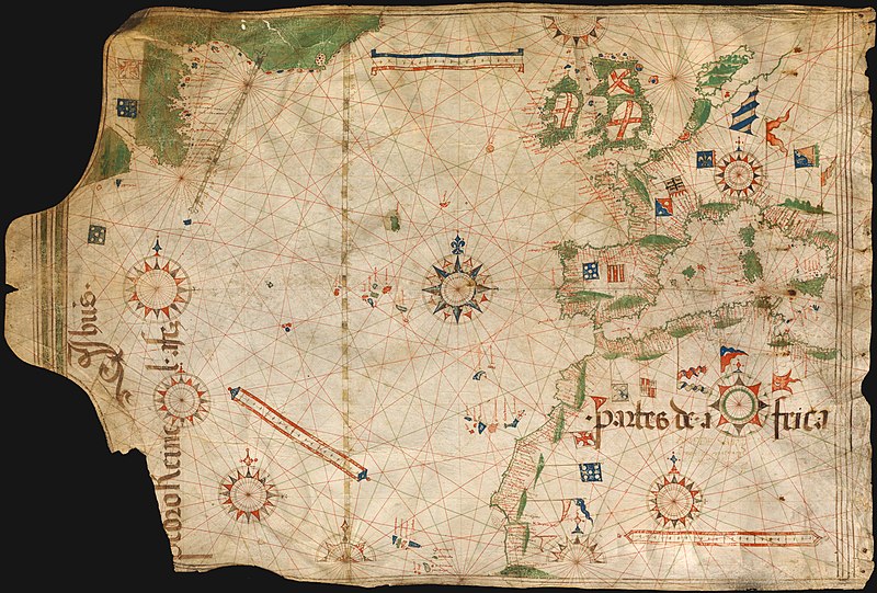
Dosya:Pedro Reinel 1504.jpg

Bu önizlemenin boyutu: 800 × 541 piksel. Diğer çözünürlükler: 320 × 216 piksel | 640 × 433 piksel | 1.024 × 693 piksel | 1.280 × 866 piksel | 2.560 × 1.732 piksel | 3.418 × 2.312 piksel.
Tam çözünürlük ((3.418 × 2.312 piksel, dosya boyutu: 6 MB, MIME tipi: image/jpeg))

|
Bu bir seçkin resimdir. Vikipedi topluluğu tarafından güzel, şaşırtıcı, etkileyici ve/veya bilgilendirici bulunan bu resme seçkin resim statüsü verilmiş ve kullanıldığı maddeye önemli ölçüde katkı sağladığına karar verilmiştir. Eğer benzer kalitede özgür lisans etiketli bir resminiz varsa, yükleyebilir ve aday gösterebilirsiniz. |
| Bu resim 13 Aralık 2011 tarihinde Türkçe Vikipedi'de günün seçkin resmi olmuştur. |
| Bu resim 18 Ocak 2013 tarihinde Türkçe Vikipedi'de günün seçkin resmi olmuştur. |
| Bu resim 10 Eylül 2018 tarihinde Türkçe Vikipedi'de günün seçkin resmi olmuştur. |
Dosya geçmişi
Dosyanın herhangi bir zamandaki hâli için ilgili tarih/saat kısmına tıklayın.
| Tarih/Saat | Küçük resim | Boyutlar | Kullanıcı | Yorum | |
|---|---|---|---|---|---|
| güncel | 20.40, 11 Ekim 2008 |  | 3.418 × 2.312 (6 MB) | Alvesgaspar | {{Information |Description=Portuguese nautical chart by Pedro Reinel, c. 1504 |Source=Bayerische Staatsbibliothek, Munchen |Date=c. 1504 |Author=Pedro Reinel |Permission=below |other_versions= }} Category:Photos by Alvesgaspar Category:Old charts |
Dosya kullanımı
Bu görüntü dosyasına bağlantısı olan sayfalar:
- Pedro Reinel
- Kullanıcı mesaj:Alvesgaspar
- Vikipedi:Günün seçkin resmi/Aralık 2011
- Vikipedi:Günün seçkin resmi/Eylül 2018
- Vikipedi:Günün seçkin resmi/Ocak 2013
- Vikipedi:Seçkin resim adayları/Arşiv/Ocak 2010
- Vikipedi:Seçkin resim adayları/Pedro Reinel 1504.jpg
- Vikipedi:Seçkin resimler/Ana sayfaya çıkmış resimler/2011 listesi
- Vikipedi:Seçkin resimler/Ana sayfaya çıkmış resimler/2013 listesi
- Vikipedi:Seçkin resimler/Çizimler, diyagramlar ve haritalar/Haritalar
- Şablon:GSR/2011-12-13
- Şablon:GSR/2013-01-18
- Şablon:GSR/2018-09-10
Küresel dosya kullanımı
Aşağıdaki diğer vikiler bu dosyayı kullanır:
- bn.wikipedia.org üzerinde kullanımı
- crh.wikipedia.org üzerinde kullanımı
- cs.wikipedia.org üzerinde kullanımı
- cv.wikipedia.org üzerinde kullanımı
- de.wikipedia.org üzerinde kullanımı
- en.wikipedia.org üzerinde kullanımı
- User:Alvesgaspar
- Pedro Reinel
- History of cartography
- Portal:Maps/Selected picture
- Wikipedia:Featured pictures/Diagrams, drawings, and maps/Maps
- Wikipedia:Featured pictures thumbs/13
- Wikipedia:Featured picture candidates/October-2008
- Wikipedia:Featured picture candidates/Image:Pedro Reinel 1504.jpg
- Wikipedia:Wikipedia Signpost/2008-11-08/Features and admins
- Wikipedia:Wikipedia Signpost/2008-11-08/SPV
- Portal:Maps/Selected picture/46
- Wikipedia:Picture of the day/June 2009
- Template:POTD/2009-06-18
- User talk:Alvesgaspar/archive1
- User:Peter Mercator/Map gallery
- Portuguese Renaissance
- Wikipedia:GLAM/NHMandSM/booklet
- Portal:Maps
- Wikipedia:Wikipedia Signpost/Single/2008-11-08
- en.wiktionary.org üzerinde kullanımı
- eo.wikipedia.org üzerinde kullanımı
- Vikipedio:Bildo de la tago/2009 01
- Vikipedio:Bildo de la tago/2009 02
- Pedro Reinel
- Vikipedio:Bildo de la tago/2011 02
- Vikipedio:Bildo de la tago/2011 01
- Vikipedio:Bildo de la tago/2010 02
- Vikipedio:Bildo de la tago/2010 01
- Vikipedio:Bildo de la tago/2012 02
- Vikipedio:Bildo de la tago/2012 01
- Vikipedio:Bildo de la tago2/indekso/3
- Ŝablono:Bildo de la Tago2/128
- es.wikipedia.org üzerinde kullanımı
- es.wiktionary.org üzerinde kullanımı
- fi.wikipedia.org üzerinde kullanımı
- fr.wikipedia.org üzerinde kullanımı
- fr.wiktionary.org üzerinde kullanımı
- gl.wikipedia.org üzerinde kullanımı
Bu dosyanın daha fazla küresel kullanımını görüntüle.


