
Dosya:Ohio Country en.png
Bu önizlemenin boyutu: 793 × 599 piksel. Diğer çözünürlükler: 318 × 240 piksel | 635 × 480 piksel | 1.016 × 768 piksel | 1.217 × 920 piksel.
Tam çözünürlük ((1.217 × 920 piksel, dosya boyutu: 1,41 MB, MIME tipi: image/png))
Bu dosya Wikimedia Commons'ta bulunmaktadır. Dosyanın açıklaması aşağıda gösterilmiştir. Commons, serbest/özgür telifli medya dosyalarının bulundurulduğu depodur. Siz de yardım edebilirsiniz. |
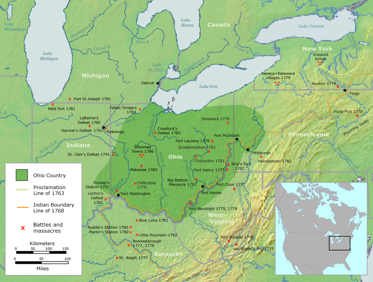
| Açıklama | Map of the Ohio Country (English version) | ||||
| Tarih | |||||
| Kaynak | Own work by Nikater, submitted to the public domain. Background map courtesy of Demis, www.demis.nl and Wilcomb E. Washburn (Hrsg.) Handbook of North American Indians. Vol. 4: History of Indian-White Relations. Smithsonian Institution Press, Washington D.C. 1988. ISBN 0-16004-583-5 | ||||
| Yazar | User:Nikater | ||||
| İzin (Bu dosyanın tekrar kullanımı) |
|
||||
| Diğer sürümler | Deutsch |
Dosya geçmişi
Dosyanın herhangi bir zamandaki hâli için ilgili tarih/saat kısmına tıklayın.
| Tarih/Saat | Küçük resim | Boyutlar | Kullanıcı | Yorum | |
|---|---|---|---|---|---|
| güncel | 06.20, 21 Eylül 2007 | | 1.217 × 920 (1,41 MB) | Nikater | {{Information |Description=Map of the Ohio Country (English version) |Source=Own work by Nikater, submitted to the public domain. Background map courtesy of Demis, www.demis.nl and Wilcomb E. Washburn (Hrsg.) ''Handbook of North American Indians.'' Vol. 4 |
| 11.50, 20 Eylül 2007 |  | 1.217 × 920 (1,41 MB) | Nikater | {{Information |Description=Map of the Ohio Country (English version) |Source=Own work by Nikater, submitted to the public domain. Background map courtesy of Demis, www.demis.nl and Wilcomb E. Washburn (Hrsg.) ''Handbook of North American Indians.'' Vol. 4 | |
| 20.21, 17 Eylül 2007 |  | 1.217 × 920 (1,41 MB) | Nikater | {{Information |Description=Map of the Ohio Country (English version) |Source=Own work by Nikater, submitted to the public domain. Background map courtesy of Demis, www.demis.nl and Wilcomb E. Washburn (Hrsg.) ''Handbook of North American Indians.'' Vol. 4 | |
| 20.05, 17 Eylül 2007 |  | 1.217 × 920 (1,41 MB) | Nikater | {{Information |Description=Map of the Ohio Country (English version) |Source=Own work by Nikater, submitted to the public domain. Background map courtesy of Demis, www.demis.nl and Wilcomb E. Washburn (Hrsg.) ''Handbook of North American Indians.'' Vol. 4 |
Dosya kullanımı
Bu görüntü dosyasına bağlantısı olan sayfalar:
Küresel dosya kullanımı
Aşağıdaki diğer vikiler bu dosyayı kullanır:
- ar.wikipedia.org üzerinde kullanımı
- arz.wikipedia.org üzerinde kullanımı
- ast.wikipedia.org üzerinde kullanımı
- bn.wikipedia.org üzerinde kullanımı
- ca.wikipedia.org üzerinde kullanımı
- cs.wikipedia.org üzerinde kullanımı
- en.wikipedia.org üzerinde kullanımı
- es.wikipedia.org üzerinde kullanımı
- fr.wikipedia.org üzerinde kullanımı
- gl.wikipedia.org üzerinde kullanımı
- id.wikipedia.org üzerinde kullanımı
- ja.wikipedia.org üzerinde kullanımı
- ko.wikipedia.org üzerinde kullanımı
- ms.wikipedia.org üzerinde kullanımı
- no.wikipedia.org üzerinde kullanımı
- pl.wikipedia.org üzerinde kullanımı
- ro.wikipedia.org üzerinde kullanımı
- ru.wikipedia.org üzerinde kullanımı
- so.wikipedia.org üzerinde kullanımı
- sq.wikipedia.org üzerinde kullanımı
- sv.wikipedia.org üzerinde kullanımı
- www.wikidata.org üzerinde kullanımı