
Dosya:Klondike Gold Rush map.png
Tam çözünürlük ((854 × 660 piksel, dosya boyutu: 859 KB, MIME tipi: image/png))
Bu dosya Wikimedia Commons'ta bulunmaktadır. Dosyanın açıklaması aşağıda gösterilmiştir. Commons, serbest/özgür telifli medya dosyalarının bulundurulduğu depodur. Siz de yardım edebilirsiniz. |
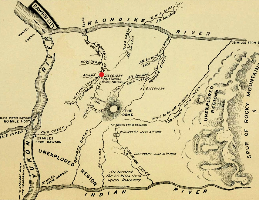
| Açıklama | Map of Klondike River and gold bearing creeks, from an 1897 guidebook for gold seekers during the Klondike Gold Rush. Claimed and unexplored regions are marked[1] The gold flowed into the creeks from the dome in the middle.[2] Bonanza is the creek closest to Dawson City and discovery claim is in the middle of it |
| Tarih | |
| Kaynak | |
| Yazar |
|
| Bu rötuşlanmış bir resim olup, resmin özgün hâli üzerinde oynama yapılarak elde edilmiştir. Yapılan değişiklikler: png (from original book), levels, crop, rotate.Resmin özgün hâline şuradan erişilebilir: Klondike Gold Rush map.jpg. Resimdeki düzenlemeler Borrow-188 tarafından yapılmıştır.
|
This Canadian work is in the public domain in Canada because its copyright has expired due to one of the following:
it was not subject to Crown copyright, and
|
 |
References
Orijinal yükleme günlüğü
This image is a derivative work of the following images:
- File:Klondike_Gold_Rush_map.jpg licensed with PD-Canada
- 2010-03-02T20:15:43Z Zanka 944x602 (101938 Bytes) {{Information |Description= The Klondike Gold Field from the book "Klondike. The Chicago Record's book for gold seekers (1897)" p.14 |Source=http://www.archive.org/details/klondikechicagor00chic |Date=1897 |Author=unknown |Pe
Uploaded with derivativeFX
Dosya geçmişi
Dosyanın herhangi bir zamandaki hâli için ilgili tarih/saat kısmına tıklayın.
| Tarih/Saat | Küçük resim | Boyutlar | Kullanıcı | Yorum | |
|---|---|---|---|---|---|
| güncel | 13.26, 4 Ocak 2014 | | 854 × 660 (859 KB) | Soerfm | Red dot |
| 14.51, 22 Ağustos 2011 |  | 854 × 662 (870 KB) | Soerenfm | Cropped in either end | |
| 18.19, 21 Ağustos 2011 |  | 1.000 × 662 (958 KB) | Soerenfm | Enhange contrast | |
| 14.01, 23 Aralık 2010 |  | 3.013 × 2.033 (1,66 MB) | Borrow-188 | {{Information |Description=The Klondike Gold Field from the book "Klondike. The Chicago Record's book for gold seekers (1897)" p.14 |Source=*File:Klondike_Gold_Rush_map.jpg |Date=2010-12-23 14:00 (UTC) |Author=*File:Klondike_Gold_Rush_map.jpg: |
Dosya kullanımı
Bu görüntü dosyasına bağlantısı olan sayfalar:
Küresel dosya kullanımı
Aşağıdaki diğer vikiler bu dosyayı kullanır:
- en.wikipedia.org üzerinde kullanımı
- ro.wikipedia.org üzerinde kullanımı
- ru.wikipedia.org üzerinde kullanımı
- uk.wikipedia.org üzerinde kullanımı