
Dosya:Gulf of Izmit, Turkey.JPG

Bu önizlemenin boyutu: 800 × 532 piksel. Diğer çözünürlükler: 320 × 213 piksel | 640 × 425 piksel | 1.024 × 681 piksel | 1.280 × 851 piksel | 2.560 × 1.701 piksel | 4.288 × 2.850 piksel.
Tam çözünürlük ((4.288 × 2.850 piksel, dosya boyutu: 2,6 MB, MIME tipi: image/jpeg))
Bu dosya Wikimedia Commons'ta bulunmaktadır. Dosyanın açıklaması aşağıda gösterilmiştir. Commons, serbest/özgür telifli medya dosyalarının bulundurulduğu depodur. Siz de yardım edebilirsiniz. |
Özet
| Açıklama |
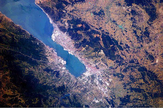
English: This astronaut photograph highlights the metropolitan area of Izmit along the northern and eastern shores of the Sea of Marmara, at the end of the Gulf of Izmit. Commercial and industrial centres—including petroleum refineries and automobile factories—are recognizable by large structures with white rooftops. The smaller city of Gölcük on the southern shoreline of the Gulf is the location of a Turkish naval facility and another automobile factory. Both urban areas are built primarily on flat lowlands adjacent to the Gulf, with green vegetation marking highland areas to the north of Izmit and south of Gölcük. |
| Tarih | |
| Kaynak | NASA Earth Observatory |
| Yazar | ISS Expedition 24 crew |
| Kamera pozisyonu | | Bu ve diğer görüntülerin konumlarını şurada belirle: OpenStreetMap |
|---|
Bu görüntü veya video ABD Ulusal Havacılık ve Uzay Dairesi (NASA) Johnson Space Centertarafından Fotoğraf ID: ISS024-E-10162 ile kataloğa alınmıştır. Bu etiket, ekli çalışmanın telif hakkı durumunu göstermez. Normal bir telif hakkı etiketi hâlâ gereklidir. Commons:Lisanslama sayfasına bakın. Diğer diller:
|
Image acquired with a Nikon D2Xs digital camera using a 180 mm lens, and is provided by the ISS Crew Earth Observations experiment and Image Science & Analysis Laboratory, Johnson Space Center.
Lisanslama
| Bu dosya NASA tarafından üretildiği için kamu malıdır. Aksi belirtilmediği sürece "NASA tarafından üretilen malzemenin telif hakkı olmadığı" NASA telif politikasında belirtilmiştir. (Bkz. Template:PD-USGov, NASA copyright policy page veya JPL Image Use Policy.) | ||
 |
Uyarılar:
|
Dosya geçmişi
Dosyanın herhangi bir zamandaki hâli için ilgili tarih/saat kısmına tıklayın.
| Tarih/Saat | Küçük resim | Boyutlar | Kullanıcı | Yorum | |
|---|---|---|---|---|---|
| güncel | 09.56, 23 Ağustos 2010 | | 4.288 × 2.850 (2,6 MB) | Originalwana | {{Information |Description={{en|1=This astronaut photograph highlights the metropolitan area of Izmit along the northern and eastern shores of the Sea of Marmara, at the end of the Gulf of Izmit. [[:Category:Commerc |
Dosya kullanımı
Bu görüntü dosyasına bağlantısı olan sayfalar:
Küresel dosya kullanımı
Aşağıdaki diğer vikiler bu dosyayı kullanır:
- ar.wikipedia.org üzerinde kullanımı
- az.wikipedia.org üzerinde kullanımı
- ba.wikipedia.org üzerinde kullanımı
- bg.wikipedia.org üzerinde kullanımı
- bn.wikipedia.org üzerinde kullanımı
- ca.wikipedia.org üzerinde kullanımı
- ceb.wikipedia.org üzerinde kullanımı
- cs.wikipedia.org üzerinde kullanımı
- en.wikipedia.org üzerinde kullanımı
- es.wikipedia.org üzerinde kullanımı
- eu.wikipedia.org üzerinde kullanımı
- fa.wikipedia.org üzerinde kullanımı
- fr.wikipedia.org üzerinde kullanımı
- he.wikipedia.org üzerinde kullanımı
- hr.wikipedia.org üzerinde kullanımı
- id.wikipedia.org üzerinde kullanımı
- ilo.wikipedia.org üzerinde kullanımı
- it.wikipedia.org üzerinde kullanımı
- ka.wikipedia.org üzerinde kullanımı
- mt.wikipedia.org üzerinde kullanımı
- nl.wikipedia.org üzerinde kullanımı
- nn.wikipedia.org üzerinde kullanımı
- ru.wikipedia.org üzerinde kullanımı
- tr.wikivoyage.org üzerinde kullanımı
- www.wikidata.org üzerinde kullanımı
- zh.wikipedia.org üzerinde kullanımı