
Dosya:Tokyo L7 lrg.jpg

Bu önizlemenin boyutu: 600 × 600 piksel. Diğer çözünürlükler: 240 × 240 piksel | 480 × 480 piksel | 1.000 × 1.000 piksel.
Tam çözünürlük ((1.000 × 1.000 piksel, dosya boyutu: 511 KB, MIME tipi: image/jpeg))
Bu dosya Wikimedia Commons'ta bulunmaktadır. Dosyanın açıklaması aşağıda gösterilmiştir. Commons, serbest/özgür telifli medya dosyalarının bulundurulduğu depodur. Siz de yardım edebilirsiniz. |
Özet
| Açıklama |
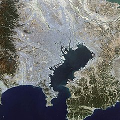
English: This false-color Landsat 7 image shows (a large part of) the greater Tokyo metropolitan area, situated on the eastern shore of the Japanese island of Honshu. The large Tokyo Bay dominates the center of this scene, and if you look closely you can see boats and their wakes on the water. The greater Tokyo area fans out in a crescent shape around the western, northern, and eastern shores of Tokyo Bay. Greater Tokyo is bordered to the west by rugged mountains and to the east by the vast expanse of the Pacific Ocean.
The greater metropolis area is comprised of Tokyo prefecture, situated on the northwestern shore of Tokyo Bay, and the three neighboring prefectures of Kanagawa to the south, Saitama to the north, and Chiba to the east and southeast across Tokyo Bay. Over the last 400 years, Japan’s National Capital Region has evolved into a large, self-governing unit consisting of 26 cities, 5 towns, and 8 villages. The region is home to some 38 million people in 2018 (more than a quarter of Japan’s whole population) in a metropolitan area spanning 14,034 square km. 日本語: 東京湾の衛星画像(2002年)人工衛星「NASA Earth Observatory」による。 |
| Tarih | |
| Kaynak | Earth Observatory |
| Yazar | Image courtesy Ron Beck, USGS Eros Data Center Satellite Systems Branch |
Lisanslama
| Bu dosya NASA tarafından üretildiği için kamu malıdır. Aksi belirtilmediği sürece "NASA tarafından üretilen malzemenin telif hakkı olmadığı" NASA telif politikasında belirtilmiştir. (Bkz. Template:PD-USGov, NASA copyright policy page veya JPL Image Use Policy.) | ||
 |
Uyarılar:
|
Dosya geçmişi
Dosyanın herhangi bir zamandaki hâli için ilgili tarih/saat kısmına tıklayın.
| Tarih/Saat | Küçük resim | Boyutlar | Kullanıcı | Yorum | |
|---|---|---|---|---|---|
| güncel | 14.25, 18 Kasım 2008 | | 1.000 × 1.000 (511 KB) | Jyusin | {{Information |Description={{en|1=Tokyo}} {{ja|1=東京}} |Source=[http://earthobservatory.nasa.gov/IOTD/view.php?id=2854 Earth Observatory] |Author=NASA |Date= |Permission= |other_versions= }} <!--{{ImageUpload|full}}--> |
Dosya kullanımı
Bu görüntü dosyasına bağlantısı olan sayfalar:
Küresel dosya kullanımı
Aşağıdaki diğer vikiler bu dosyayı kullanır:
- az.wikipedia.org üzerinde kullanımı
- de.wikipedia.org üzerinde kullanımı
- es.wikipedia.org üzerinde kullanımı
- fr.wikipedia.org üzerinde kullanımı
- hu.wikipedia.org üzerinde kullanımı
- it.wikipedia.org üzerinde kullanımı
- ja.wikipedia.org üzerinde kullanımı
- pt.wikipedia.org üzerinde kullanımı
- simple.wikipedia.org üzerinde kullanımı
- vi.wikipedia.org üzerinde kullanımı
- zh.wikipedia.org üzerinde kullanımı